
O/S Maps of Codnor Area
View the old maps to see how Codnor has changed over the years.
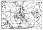
O/S Map of Codnor1921
Click the map icon opposite to view
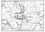
O/S Map of Codnor1901
Click the map icon opposite to view
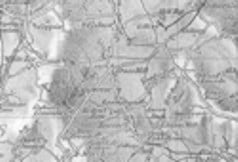
O/S Map of Codnor1884
Click the map icon opposite to view
Sandersons Map of Codnor 1835
Click the map icon opposite to view
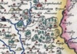
Map of Codnor Circa 1767
Click the map icon opposite to view

Christopher Saxton's 1583 Map
Click the map icon opposite to view
Images produced from the www.old-maps.co.uk service with permission of Landmark Information Group Ltd. and Ordnance Survey